


20210131

fredodlageo
User
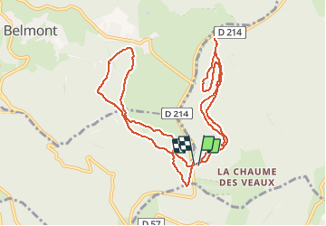

Length
11.4 km

Max alt
1090 m

Uphill gradient
244 m
Km-Effort
14.6 km

Min alt
1021 m

Downhill gradient
237 m
Boucle
Yes
Creation date :
2021-01-31 08:51:12.0
Updated on :
2021-02-01 19:02:48.933
1h33
Difficulty : Unknown

FREE GPS app for hiking
 SityTrail
IGN / Geographical institutes
SityTrail Plus
The world is yours!
About
Trail Cross-country skiing of 11.4 km to be discovered at Grand Est, Bas-Rhin, Le Hohwald. This trail is proposed by fredodlageo.
Description
Sortie champ du deux
Positioning
Country:
France
Region :
Grand Est
Department/Province :
Bas-Rhin
Municipality :
Le Hohwald
Location:
Unknown
Start:(Dec)
Start:(UTM)
371976 ; 5361268 (32U) N.
Comments